Hurricane Nolo Tests El Niño Forecasts
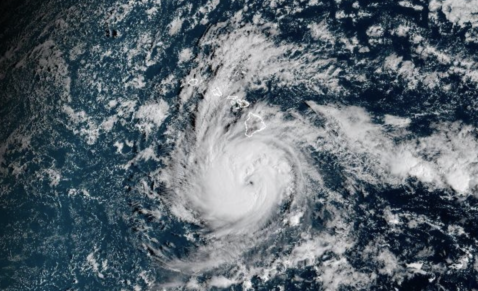
Hurricane Nolo Tests El Niño Forecasts
Hurricane Nolo is the kind of storm that turns climate science from background noise into an immediate planning problem. For coastal residents, emergency managers, insurers, and energy operators, the threat is not just wind speed or rainfall totals. It is uncertainty. A Pacific hurricane shaped by El Niño conditions can intensify quickly, bend toward unusual tracks, and expose how fragile modern readiness still is when oceans run unusually warm.
The larger story is bigger than one storm. Hurricane Nolo is a stress test for forecasting systems, public communication, and coastal infrastructure in an era when seasonal patterns are becoming harder to translate into simple risk categories.
- Hurricane Nolo highlights the Pacific risk multiplier: warm ocean water and favorable atmospheric patterns can give storms more fuel.
El Niñocan shift storm behavior: it often changes wind patterns, storm tracks, and intensification potential across the Pacific.- Forecasting is improving, but communication remains the weak link: people need usable risk guidance, not just cone graphics.
- The economic stakes are rising: ports, agriculture, tourism, insurance, and power grids all face cascading disruption.
Why Hurricane Nolo Became a Pacific Warning Shot
Pacific hurricanes do not always command the same national attention as Atlantic storms, but that can be misleading. The eastern and central Pacific can generate powerful cyclones, and when ocean heat is abundant, storms can evolve faster than communities expect. Sea surface temperature, vertical wind shear, atmospheric moisture, and steering currents all work together to determine whether a system stays offshore, clips islands, or becomes a direct coastal threat.
What makes Hurricane Nolo especially important is the broader climate setup. During El Niño, warmer-than-average water in the equatorial Pacific can rearrange atmospheric circulation. That does not mean every storm becomes catastrophic. It does mean the baseline environment can become more favorable for certain storms to strengthen or take less familiar routes.
The key insight is simple: a warmer Pacific does not guarantee disaster, but it raises the ceiling on what a storm can become.
That ceiling matters. Emergency planning often relies on history: the last big storm, the known flood zone, the traditional evacuation route. But if the atmosphere is operating in a different mode, old assumptions can become liabilities.
Hurricane Nolo and El Niño Risk Are Now a Planning Problem
El Niño is not a storm factory switch. It is more like a climate-scale rebalancing of heat and wind. In some basins, it suppresses hurricane activity. In parts of the Pacific, it can support more storm formation or alter where storms intensify. The danger comes when public understanding lags behind meteorological nuance.
For residents, the phrase El Niño often means vague expectations: wetter winters, warmer water, odd weather. For forecasters, it means a complex set of signals that must be translated into actionable warnings. Hurricane Nolo sits in that gap between scientific signal and public behavior.
The Warm Water Problem
Hurricanes feed on ocean heat. When sea surface temperatures are elevated, storms can draw more energy from the upper ocean. If warm water extends deeper below the surface, a storm may be less likely to churn up cooler water that would normally weaken it. That is one reason rapid intensification has become such a serious concern.
Rapid intensification is not just a technical classification. It is a logistics nightmare. It compresses decision time for evacuations, port closures, hospital preparations, school shutdowns, and grid hardening. A storm that jumps categories close to land can turn a manageable forecast into a full-scale emergency.
The Wind Shear Question
Vertical wind shear can tear developing hurricanes apart by disrupting their structure. But when shear is low, storms can stack vertically, organize efficiently, and strengthen. During some El Niño patterns, regions of the Pacific may experience wind environments more supportive of cyclone growth.
This is where nuance matters. A single climate pattern does not dictate one outcome everywhere. Local atmospheric conditions still decide the final result. But when warm water and favorable winds overlap, storms like Hurricane Nolo deserve close scrutiny.
The Track Uncertainty Trap
Forecast tracks are improving, but they are still probabilistic. A small change in steering currents can make the difference between a storm that stays safely offshore and one that brings flooding rain, storm surge, or destructive surf. The public often sees the forecast cone as a boundary, but risk does not stop at a line.
Pro Tip: If you are in a storm-prone region, do not treat the forecast cone as a safe-or-unsafe map. Watch watches, warnings, rainfall forecasts, surge projections, and local emergency instructions. Wind is only one part of the hazard.
The Forecasting Tech Is Better Than Ever
The modern hurricane forecast stack is astonishingly sophisticated. Satellites monitor cloud structure, ocean temperatures, water vapor, lightning, and storm motion. Aircraft reconnaissance can sample pressure and wind fields when storms threaten populated areas. Numerical weather prediction models simulate possible futures using enormous datasets and high-performance computing.
Yet storms still surprise us. That is not because meteorology is failing. It is because hurricanes are dynamic systems interacting with a chaotic atmosphere and an ocean that is no longer behaving like the twentieth-century baseline many communities were built around.
Machine learning is becoming more relevant here. New forecasting tools can identify patterns in historical storm behavior, satellite imagery, and model ensembles. But AI does not remove uncertainty. It can sharpen probabilities, flag intensification risks, and help forecasters triage scenarios, but human expertise remains essential.
The best forecast is not the one with the most data. It is the one that helps people make better decisions before conditions deteriorate.
What Hurricane Nolo Means for Coastal Infrastructure
The physical damage from a Pacific hurricane is only one layer of risk. The deeper problem is systemic fragility. Modern coastal economies depend on synchronized networks: ports, fuel terminals, airports, telecom systems, water infrastructure, hospitals, roads, and power grids. A storm does not need to flatten a city to create serious disruption.
Heavy rain can overwhelm drainage systems designed for older precipitation assumptions. High surf can damage coastal roads and tourism districts. Power outages can interrupt water pumping and communications. Agricultural regions can face crop loss from wind, flooding, or saltwater intrusion. Insurers may respond by raising premiums, restricting coverage, or exiting markets they consider too volatile.
That is why Hurricane Nolo should be treated as a resilience case study, not just a weather event. The question is no longer whether a community can survive one storm. The question is whether it can keep functioning as high-impact events become more expensive and harder to predict.
Emergency Management Needs Faster Decision Loops
Storm preparation is increasingly a race against time. Local officials must decide when to open shelters, issue evacuation guidance, stage equipment, protect vulnerable populations, and coordinate with utilities. If intensification happens late, hesitation becomes costly.
Communities should invest in pre-scripted response thresholds. For example, if forecast rainfall exceeds a certain level, flood-prone roads close automatically. If wind probabilities cross a defined threshold, utilities pre-position repair crews. If hospitals expect access issues, backup transport plans activate. These are not glamorous upgrades, but they reduce confusion when pressure is highest.
Public Messaging Must Get Less Abstract
Too much storm communication still depends on categories. The Saffir-Simpson Hurricane Wind Scale is useful, but it can distort risk by focusing attention on sustained wind. Many deadly hurricane impacts come from water: storm surge, flash flooding, landslides, and dangerous surf.
A better warning system tells people what to do, where, and when. It explains local consequences in plain language. It repeats uncertainty without sounding indecisive. Most importantly, it reaches people who may not be watching traditional broadcasts, including renters, tourists, non-English speakers, elderly residents, outdoor workers, and people without reliable transportation.
Hurricane Nolo Shows the Insurance Reality Check
The insurance market is one of the clearest signals that climate risk is becoming financial risk. When storms grow more damaging or unpredictable, insurers reassess pricing. That can mean higher premiums, larger deductibles, stricter underwriting, or reduced availability of coverage in high-risk zones.
For homeowners and businesses, this turns hurricane risk into a balance-sheet problem. A property may be physically intact but financially strained by rising insurance costs. Municipal governments may find it harder to borrow for infrastructure if climate exposure looks unmanaged. Developers may face tougher scrutiny over coastal projects.
This is where the politics become unavoidable. Building codes, zoning decisions, seawalls, wetland restoration, managed retreat, and disaster aid are all choices about who pays for risk. Hurricane Nolo reinforces a hard truth: the atmosphere may create the hazard, but policy decides the scale of the loss.
What Comes Next After Hurricane Nolo
The future of Pacific hurricane risk will depend on both natural climate variability and long-term warming. El Niño will come and go. Ocean heat trends, coastal development, and infrastructure vulnerability will continue shaping outcomes. That combination means storm seasons can no longer be judged only by the number of named systems. One well-placed storm can define an entire year.
The practical path forward is not panic. It is modernization. Forecasting agencies need sustained investment in satellites, ocean sensors, computing, and field observations. Cities need drainage upgrades, resilient power systems, heat and flood planning, and stronger building standards. Households need realistic preparedness plans that assume disruptions may last longer than official minimums suggest.
For readers in vulnerable regions, the takeaway is direct: build your plan before the forecast becomes urgent. Know your evacuation zone, protect documents, prepare medications, maintain backup power where possible, and follow local emergency guidance. Storm readiness is not just canned food and flashlights. It is decision-making before fear enters the room.
The Bottom Line on Hurricane Nolo
Hurricane Nolo matters because it illustrates the new shape of weather risk in the Pacific: warmer water, shifting atmospheric patterns, better forecasts, and higher consequences when communities are underprepared. El Niño may help explain the environment around the storm, but the human challenge is readiness.
The lesson is not that every Pacific storm will become extreme. The lesson is that the margin for complacency is shrinking. Forecast models will improve. Satellites will get sharper. Emergency alerts will become more targeted. But none of that matters if people, businesses, and governments treat each storm as an isolated event instead of part of a larger risk transition.
Hurricane Nolo is a warning with a name: the Pacific is changing, and resilience has to move faster than the next forecast update.
The information provided in this article is for general informational purposes only. While we strive for accuracy, we make no guarantees about the completeness or reliability of the content. Always verify important information through official or multiple sources before making decisions.


