Australia Flood Warning Escalates
Australia Flood Warning Escalates
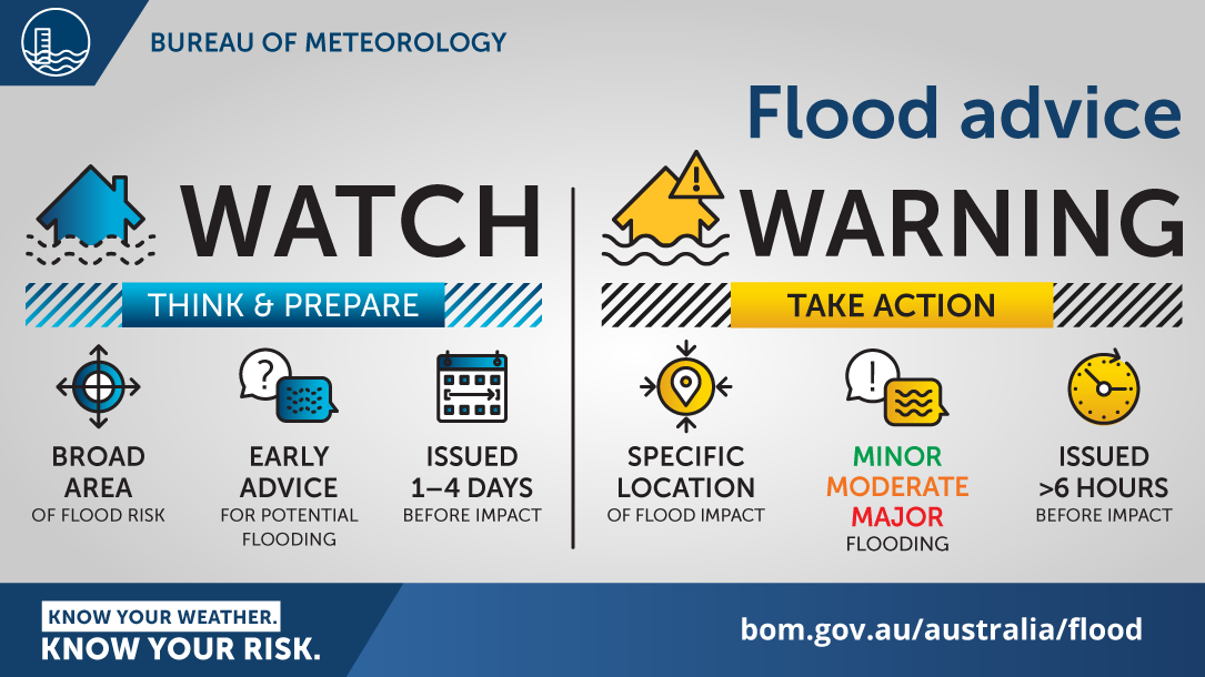
Australia flood warning alerts are no longer background noise – they are a live test of how communities, infrastructure and emergency systems handle a widening burst of severe weather. Heavy rain across parts of Queensland, New South Wales and Tasmania is raising the risk of flash flooding, travel disruption and fast-moving local emergencies. For residents, the challenge is brutally practical: roads can close in minutes, rivers can rise overnight and official advice can shift fast. For businesses and local authorities, this is also a systems story about resilience, forecasting and response speed. When the Bureau of Meteorology issues severe weather warnings across multiple states, the signal is clear: conditions are unstable, impacts can stack quickly and preparation matters before the rain peaks, not after.
- Heavy rainfall is threatening parts of Queensland, New South Wales and Tasmania, with flash flooding a central risk.
- The Australia flood warning picture is highly dynamic, meaning local conditions may worsen faster than broad forecasts suggest.
- Transport, power, schools and supply chains can all be disrupted even in areas that avoid major river flooding.
- Residents should monitor official alerts closely and prepare for rapid changes in road access and emergency advice.
Why this Australia flood warning matters beyond the forecast
Severe weather coverage often gets flattened into one simple headline: lots of rain is coming. That misses the real story. An Australia flood warning is not just a weather update – it is an operational alert for households, councils, emergency responders and anyone moving through affected regions. The danger is often less about the total rainfall figure and more about where it falls, how quickly it falls and what the ground can absorb.
When catchments are already wet, even moderate additional rainfall can trigger dangerous runoff. In urban areas, drainage systems can be overwhelmed. In regional areas, creeks and low crossings can become impassable with very little warning. The result is a familiar but still underestimated pattern: people assume they have more time than they do.
Severe weather is rarely just a rain event. It becomes a mobility problem, a communications problem and sometimes a life-safety problem within hours.
That is why warnings from the Bureau of Meteorology carry weight. They are not abstract risk indicators. They are early signals that compounding failures are possible: flooded roads, delayed freight, power interruptions and emergency services stretched across multiple communities at once.
Queensland, NSW and Tasmania face different versions of the same threat
One of the most important things to understand about this event is that the risk is not uniform. Queensland, New South Wales and Tasmania may all sit under the same broad severe weather narrative, but each region faces its own exposure profile.
Queensland and the flash flooding equation
In Queensland, intense bursts of rain can produce flash flooding quickly, especially in built-up areas and low-lying communities. The speed of onset is what makes these events dangerous. Water can rise across roads before drivers recognize the severity. Small waterways can turn aggressive fast. Even if major river systems do not immediately break out, short-duration downpours can still create emergency conditions.
This is where public messaging matters most. Flash flooding is often local, fast and visually deceptive. A road that looked passable an hour earlier may become a high-risk crossing with little visible warning beyond water depth and current.
New South Wales and compounding transport disruption
For New South Wales, the threat often extends beyond rainfall totals into network disruption. Road closures, rail delays and freight interruptions can ripple outward, affecting schools, hospitals, regional commerce and daily commuting. If multiple districts are affected at once, the state can shift from localized inconvenience to broader logistical strain.
That matters because modern communities depend on tightly timed systems. Deliveries, staffing, health appointments and emergency access all assume road reliability. Severe rain breaks that assumption quickly.
Tasmania and the vulnerability of exposed infrastructure
Tasmania’s risk profile can be different again. Terrain, saturated ground and exposed transport links can create a sharp edge to heavy rain events. Slippery roads, swollen waterways and isolated communities can magnify the impact of what might appear, on paper, to be a smaller weather system than those seen on the mainland.
In practical terms, that means the same warning label can produce very different real-world outcomes depending on local geography and infrastructure capacity.
How severe weather warnings turn into real disruptions
Weather warnings can feel repetitive until the impacts arrive. But the pathway from forecast to disruption is usually clear. It tends to follow a familiar chain:
- Heavy rainfall begins across already vulnerable catchments or urban areas.
- Drainage and waterways fill rapidly, especially where soils are saturated.
- Road access deteriorates at low crossings, underpasses and flood-prone corridors.
- Emergency calls increase as drivers, residents and businesses encounter fast-changing conditions.
- Secondary impacts emerge, including power faults, school closures, delayed deliveries and service interruptions.
This sequence is why preparedness has to start before visible flooding arrives. Once transport access degrades, options narrow quickly. Waiting for certainty is often the same as waiting too long.
What residents should do during an Australia flood warning
The best response to an Australia flood warning is not panic. It is disciplined preparation. The goal is to reduce decision pressure when conditions deteriorate.
Prioritize movement and communication early
If travel is optional, reconsider it. If travel is necessary, leave earlier, plan alternatives and assume routes may change. Charge phones and backup batteries. Keep emergency contacts accessible without relying on a single device.
Protect the basics first
Residents in vulnerable areas should secure outdoor items, check drainage around the home and move valuables off the floor where practical. For businesses, this means backing up essential equipment, reviewing staff travel plans and preparing for short-notice disruption.
Respect road closures and floodwater
This remains one of the most repeated warnings because it remains one of the most ignored. Floodwater depth is hard to judge, road surfaces can be compromised and currents can be far stronger than they appear. A vehicle does not need much water to lose traction or be swept away.
The most dangerous flood decision is often the most ordinary one: assuming a familiar road is still safe because it usually is.
The bigger issue is climate resilience, not just one storm
Every severe rain event now lands inside a broader national debate about resilience. Whether or not one system is historically exceptional, the pattern is unmistakable: communities are being asked to cope with more frequent, more disruptive weather swings. That puts pressure not just on emergency services but on planning, insurance, drainage design, housing policy and public communications.
The Australia flood warning cycle highlights a difficult truth. Forecasting has improved, but warning quality alone cannot solve weak infrastructure or poor land-use decisions. If roads repeatedly fail, if new housing expands into vulnerable corridors or if local drainage cannot handle modern rainfall extremes, the cost of every warning goes up.
This is where weather reporting intersects with public policy. The immediate story is rain and flood risk. The deeper story is whether governments and institutions are adapting fast enough to the hazards they already know are coming.
Why the Bureau of Meteorology’s role is under sharper scrutiny
During multi-state severe weather events, the Bureau of Meteorology becomes one of the most critical public-facing institutions in the country. Its warnings shape school decisions, transport planning, local government responses and household behavior. That also means public trust is constantly being tested.
People do not just want technically accurate forecasts. They want clarity, timing and location-specific urgency. They want to know whether this is a monitor-the-situation kind of day or a cancel-your-plans-right-now kind of day. Bridging that gap between meteorological language and public action is one of the hardest jobs in crisis communication.
When warnings are timely and specific, they save lives. When they are misunderstood, delayed or dismissed, risk compounds. In that sense, an Australia flood warning is as much a communications challenge as a weather event.
What to watch over the next 24 hours
The next phase of this event will likely hinge on a few variables: whether rainfall bands stall over the same locations, how saturated local catchments already are and how quickly emergency warnings are updated as impacts emerge. Residents should pay close attention to:
- Flash flood alerts for specific towns, suburbs and road corridors.
- Rapid changes in river and creek conditions, especially overnight.
- Transport advisories affecting major roads, regional links and public transit.
- Local emergency instructions if evacuations or shelter advice are issued.
The overnight factor matters. Heavy rain after dark increases risk because visibility drops, fatigue sets in and people are more likely to underestimate changing conditions until morning reveals the damage.
The bottom line on this Australia flood warning
The immediate takeaway is simple: this weather system deserves respect. Queensland, New South Wales and Tasmania are all staring at a mix of heavy rainfall, local flooding risk and cascading disruption that can escalate quickly. But the larger lesson is even more important. Australia flood warning events are no longer rare stress tests. They are recurring reminders that preparedness, infrastructure quality and public trust in warnings now sit at the center of everyday resilience.
For households, that means treating severe weather alerts as action signals, not background information. For governments and businesses, it means recognizing that resilience is not a talking point – it is operational capacity under pressure. When heavy rain starts falling across multiple states, the difference between inconvenience and crisis often comes down to what people do in the hours before the water rises.
The information provided in this article is for general informational purposes only. While we strive for accuracy, we make no guarantees about the completeness or reliability of the content. Always verify important information through official or multiple sources before making decisions.


